From the map in Aubrey's History of Surrey, 1673.
Taken from the Geological, Historical & Topological Description of the Borough of Reigate
and Surrounding District, by R. Phillips.

Plan of Reigate town, 1786, from "Reigate Its Story Through the Ages" by Wilfrid Cooper.
Please click on the map above for a closer look.

Publisher: Samuel Lewis.
Date: circa 1835
Furthur Information: This map is from Samuel Lewis's Topographical Dictionary,
drawn by R Creighton and engraved by J & C Walker.
A map of Redhill, Reigate and the surrounding area from 1874.
Click on the map tiles above for a more detailed look.
Images produced from the
www.old-maps.co.uk service with permission of
Landmark Information Group Ltd. and
Ordnance Survey.
Copyright © and/or Database Right Landmark Information Group and Ordnance
Survey Crown Copyright and/or Database Right 2002. All rights reserved.
Taken from the Geological, Historical & Topological Description of the Borough of Reigate
and Surrounding District, by R. Phillips, 1885.

Taken from the Geological, Historical & Topological Description of the Borough of Reigate
and Surrounding District, by R. Phillips, 1885.

Map of Environs of Reigate and Redhill by Roberts & Co., circa 1900.
Please click on the map above for a closer look.

Click for a map of Gatwick. 1914. Ordnance Survey.

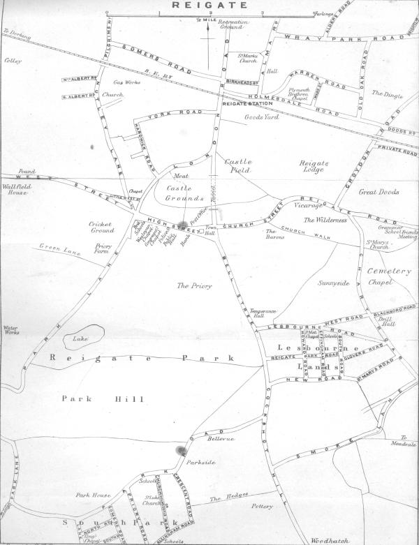
Plan of part of the Town of Reigate, 1921.
Please click on the map above for a closer look.

Surrey Sheet, 1933 with additions 1938.
Please click on the map above for a closer look.

Where the flying bombs fell in East Surrey.
The Borough In War Time. Charles W. Preston.

Plan of Reigate Parish, 1945, from "Reigate Its Story Through the Ages" by Wilfrid Cooper.
Please click on the map above for a closer look.

Map of the Borough of Reigate by G.W. May Ltd., circa 1964.
Please click on the map above for a closer look.

Map of Reigate and Redhill by Geographia Ltd. 1964.
Please click on the map above for a closer look.

Map of Reigate High Street (East), 1956.

Map of Chart Lane, turn of the century.